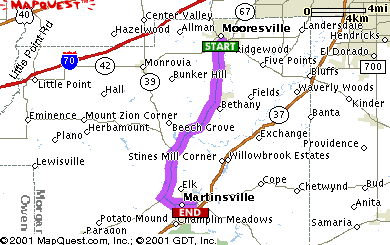
| DIRECTIONS |
DISTANCE |
| There are 0.1 miles ( 0.1km)
between the start of the directions and your origin. Use
the map below to get to IN-67 N by turning right. |
 |
| 1: |
Start out going North on IN-67 N by
turning right. |
1.0 miles ( 1.7 km) |
|
|
| 2: |
Turn LEFT onto IN-144. |
0.0 miles ( 0.0 km) |
|
|
| 3: |
Turn LEFT onto IN-67 S. |
13.6 miles ( 21.9 km) |
|
|
| 4: |
Turn LEFT onto IN-39. |
0.9 miles ( 1.4 km) |
|
|
| 5: |
Turn SLIGHT LEFT onto IN-44. |
1.3 miles ( 2.1 km) |
|
|
| There are 0.1 miles ( 0.1km)
between the end of the directions and your destination.
Use the map below to get to 1109 E COLUMBUS ST
MARTINSVILLE, IN 46151-1709. |
|
|
| TOTAL ESTIMATED TIME: |
TOTAL DISTANCE: |
| 32 minutes |
16.9 miles (
27.1km) |